
Historical land-use and spatial planning map of Riau used for geospatial analysis in the Riau One Map programme.

Participatory Land Governance and Spatial Evidence

Building Riau’s Geospatial Evidence Base

Consolidating and assessing geospatial information to support forest governance analysis, regional planning, and implementation of the One Map Policy in Riau.

  • Riau Province, with forest-area studies focused on Siak and Pelalawan Regencies
  • 2016–2017
  • Completed

Project Overview

Hutanriau implemented a geospatial data-development programme in support of Riau One Map from September 2016 to January 2017.

The project combined institutional engagement, geospatial data collection, metadata preparation, forest-area analysis, and technical reporting. Hutanriau consolidated 67 geospatial datasets in shapefile format, supported discussions with regional data custodians, developed a methodology for forest-area analysis, and applied the methodology to Siak and Pelalawan.

The programme strengthened Hutanriau’s capacity to translate fragmented spatial information into evidence relevant to forest governance, land-use planning, and regional policy discussions.

Documented reach

At a glance

67

geospatial datasets consolidated in shapefile format
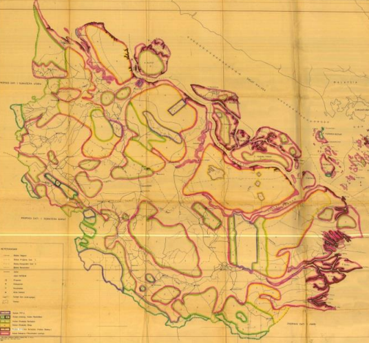
Historical output from the documented 2016–2017 programme period.

2

regencies included as forest-area study locations

Siak and Pelalawan.

1

forest-area analysis methodology developed by Hutanriau

Evidence

translated from dispersed spatial data into material for governance discussions

This is a qualitative project contribution, not a quantified policy impact.

Documented Outputs

  • One informal engagement process with regional data custodians and government institutions completed.
  • One two-day provincial focus group discussion conducted on 15–16 November 2016.
  • Sixty-seven geospatial datasets consolidated in shapefile format.
  • Basic and thematic geospatial data inventoried, selected, and classified.
  • One simplified metadata methodology prepared by WRI Indonesia.
  • One forest-area analysis methodology prepared by Hutanriau.
  • One report on the condition of geospatial data in Riau prepared.
  • One draft forest-area analysis for Siak and Pelalawan prepared.
  • Two of the project’s three agreed outputs completed.
  • The planned publication and communication output remained incomplete when the project ended.

Project Context

Unclear and inconsistent geospatial information had become a significant obstacle to effective spatial planning, forest governance, and land-use decision-making in Riau.

Government agencies and other institutions maintained different sectoral maps based on different mandates, scales, methods, and policy frameworks. Many maps circulated without adequate information about their source, date, accuracy, or legal status.

These conditions contributed to overlapping permits, unclear administrative boundaries, inconsistencies between provincial and district data, and disputes involving government institutions, private companies, and communities.

The Government of Indonesia had introduced the One Map Policy through Presidential Regulation No. 9 of 2016. WRI Indonesia supported implementation of the policy and provided a sub-grant to Hutanriau to develop geospatial data and institutional engagement in Riau.

The project combined discussion with data custodians, collection and assessment of geospatial information, metadata preparation, and forest-area analysis focused on Siak and Pelalawan.

The work was intended to create a clearer understanding of available data, identify technical and institutional gaps, and strengthen the use of spatial evidence in land and forest governance.

Objectives

  • Identify key geospatial data issues affecting forest and land governance in Riau.
  • Build communication and shared understanding among regional data custodians and government institutions.
  • Collect and organise basic and thematic geospatial information from government, private-sector, civil-society, and online sources.
  • Assess the availability, quality, consistency, metadata, and usability of geospatial datasets.
  • Develop methods for metadata preparation and forest-area analysis.
  • Prepare an initial assessment of geospatial data conditions in Riau.
  • Conduct forest-area analysis for Siak and Pelalawan Regencies.
  • Support wider implementation of the One Map Policy in Riau.

What Hutanriau Did

  • Conducted informal discussions with Bappeda Provinsi Riau and the Forest Area Consolidation Centre Region XIX Pekanbaru.
  • Organised a two-day focus group discussion on accelerating the One Map Policy through geospatial data development.
  • Facilitated discussion among provincial and district government agencies on data validity, administrative boundaries, map scales, metadata, and sectoral inconsistencies.
  • Requested and collected basic and thematic geospatial datasets from government institutions, geoportals, civil-society sources, and available archives.
  • Inventoried, selected, classified, and organised vector datasets.
  • Converted selected online geospatial data from JSON into shapefile format.
  • Prepared metadata using a simplified framework developed by WRI Indonesia.
  • Developed a forest-area analysis methodology aligned with the scope of Hutanriau’s proposal.
  • Verified forest-area shapefiles against official map attachments.
  • Clipped spatial data to Siak and Pelalawan Regencies.
  • Overlaid forest-area maps and reviewed changes in forest function, allocation, and designation.
  • Prepared a report on the condition of geospatial data in Riau.
  • Prepared a forest-area analysis for Siak and Pelalawan.
  • Conducted project monitoring, evaluation, documentation, and reporting.

Early Outcomes

Fragmented spatial information required both technical and institutional responses

The programme showed that Riau did not simply lack geospatial data. The larger problem was that datasets were dispersed across institutions, produced at different scales, updated at different times, and often lacked adequate metadata.

Data collection did not automatically produce reliable evidence

Sixty-seven datasets were consolidated, but their usability varied. Differences in source, age, scale, coordinate system, attributes, and legal status meant that the datasets required further verification before they could support policy or planning decisions.

Metadata was essential for responsible data use

The project highlighted the importance of documenting who produced a dataset, when it was created, its scale, reference system, data custodian, disclosure status, and limitations. Without this information, spatial data could easily be misinterpreted or used outside its intended purpose.

Regional engagement revealed recurring governance challenges

The focus group discussion identified recurring issues including inconsistent sectoral data, unclear administrative boundaries, different map producers, incomplete base maps, overlapping permits, and the absence of common technical standards.

Forest-area analysis required legal as well as spatial interpretation

Overlaying maps was not sufficient on its own. The analysis also had to examine forest-area decrees, changes in forest function and allocation, and their consistency with applicable regulations.

Siak and Pelalawan provided practical study areas

The two regencies enabled Hutanriau to test the methodology against multiple forest-area decrees and to compare changes in forest designation, function, and allocation over time.

Institutional timing strongly influenced project performance

The project was implemented at the end of the calendar year, when government agencies had limited availability and several officials were being replaced. This disrupted communication, delayed access to data, and reduced the time available for analysis and publication.

Clear agreement between donor and grantee was critical

Differences between WRI Indonesia and Hutanriau regarding the scope of data and methodology contributed to delays. The project demonstrated the importance of resolving methodological expectations before implementation begins.

The programme strengthened Hutanriau’s technical foundation

Despite its limitations, the project strengthened Hutanriau’s capacity in GIS, metadata, spatial database development, forest-area analysis, government engagement, and evidence-informed land governance.

Limits of the Evidence

Evidence boundary

The project verifies that sixty-seven geospatial datasets were consolidated in shapefile format during the programme period. The datasets were collected from government sources, online geoportals, civil-society sources, and archives available before the project.

The number of datasets should not be interpreted as evidence that the data were complete, current, accurate, harmonised, legally authoritative, or suitable for all analytical purposes.

Planned access to data from Bappeda Provinsi Riau did not proceed as expected. Some data were therefore obtained from online sources and previous collections rather than directly from the designated government data custodian.

The focus group discussion built initial understanding among participating institutions, but attendance was lower than planned, invitations were issued late, facilitation preparation was limited, and participants did not bring the spatial datasets requested for the meeting.

The forest-area analysis for Siak and Pelalawan was an analytical project output. It should not be presented as an official determination of forest boundaries, legal status, land rights, or compliance.

The project completed two of its three agreed outputs. The planned publication and external communication of the research results were not completed during the project period.

Engagement with Bappeda and other government institutions does not by itself demonstrate formal adoption of the findings into policy, planning instruments, or official databases.

All project data and maps are historical. Any current use requires renewed verification of date, scale, coordinate reference system, metadata, ownership, disclosure status, and compatibility with current laws and official geospatial information.

Field Documentation

Selected photographs documenting project activities, field implementation, and community participation.

Planning locally grounded environmental work in Riau?

Hutanriau collaborates with communities, donors, government agencies, research institutions, civil society organisations, and responsible private-sector partners.

Discuss a Partnership